Telegraph lines installed parallel to a road. Credit: Wikimedia Commons (https://creativecommons.org/publicdomain/zero/1.0/deed.en)
These Michigan roads trace the state’s defining moments.
Have you ever cruised down a Michigan road when, for whatever reason, you really paid attention to a particular street sign and wondered, “What’s the story behind that?” Turns out, the roads we drive every day aren’t just pavement and paint—they’re pieces of Michigan’s ever-evolving history.
From telegraph lines and territorial trails to Native leaders and concrete firsts, buckle up as we take you on a trip down six Michigan roads with names that tell the story of the state’s past.
1. Telegraph Road
Growing up, every time I heard the word “telegraph,” I would instantly think of Telegraph Road and riding down it in the backseat of my mom’s old minivan. So, despite the name being as clear as day, when my search revealed to me that it was named due to the telegraph lines that were installed alongside it, my mind was blown.
A telegraph is a device that was used to transmit messages over long distances, typically using electrical signals, lines, or radio signals. Widely used from the mid-1800s to the early 1900s, these messages were often sent in Morse code but could be sent using other codes or signaling methods, some of which allowed letters to be displayed directly instead of operators having to learn a code.
At the time, telegraphs were a revolutionary form of communication and highly important for connecting communities for trade and other economic endeavors. To keep up with its growing significance, during the mid-19th century, telegraph lines were extended south from Detroit to Monroe and north to Pontiac. Parallel roads were built to provide access for maintenance crews. Eventually, one of the most prominent of these roads became known as Telegraph Road.
After its construction and following its expansion and modernization, Telegraph Road gradually gained importance as a way to connect communities south of Detroit. Today, Telegraph Road is a major north-south highway, especially within the Detroit metropolitan area. British rock band Dire Straits used the road in their tour bus, which led to the song “Telegraph Road,” which is considered one of the band’s best songs.
2. Pontiac Trail
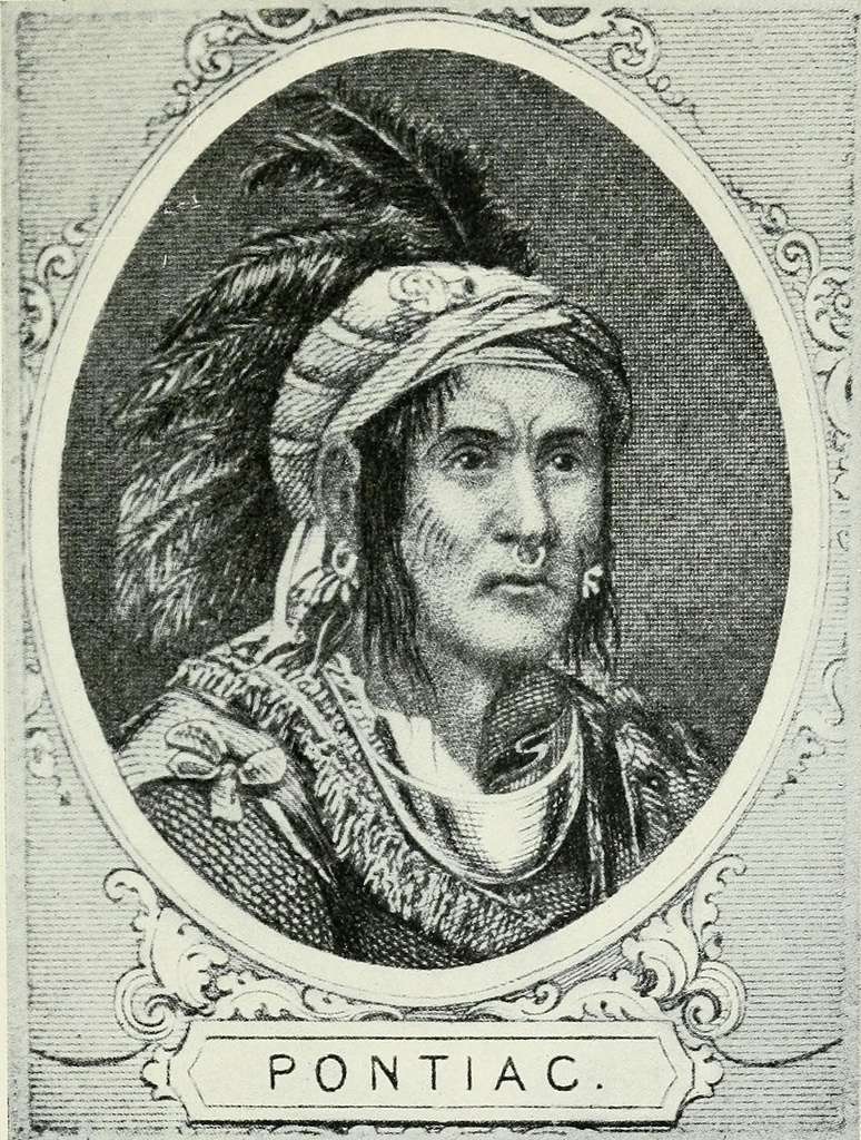
Portrait of Chief Pontiac from 1906. Credit: University of California (https://creativecommons.org/publicdomain/mark/1.0/)
Pontiac Trail is very close to my old elementary school, where we made hand turkeys while we learned about how the pilgrims and Native Americans came together for Thanksgiving, and how Pontiac Trail is named after Chief Pontiac.
Prominent Ottawa war chief Pontiac, or Obwaandi’eyaag, was known for his role in Pontiac’s Rebellion, a conflict between Native American tribes and the British following the French and Indian War. After the war, the power dynamics between the Native Americans and the British changed, with the British becoming the new dominant colonial power compared to the French, with whom the Native Americans had allied previously. Pontiac organized and led a coalition of various tribes in the Great Lakes region to resist British expansion and encroachment on their lands. This siege of Fort Detroit was ultimately unsuccessful, but it resulted in significant losses for the British and led to a peace treaty in 1766. Pontiac was well-renowned for his resistance efforts and for being part of the peace negotiations.
As for the physical trail itself, it originally served as an early footpath for Native Americans, but later evolved into a vital route for early settlers, then into a road, and now into a modern highway connecting the city of Pontiac and Ann Arbor. Some attribute the region’s growth and changing modes of transportation to the trail’s evolution. Pontiac Trail has played a vital part in the growth of nearby communities and in keeping the legacy of Chief Pontiac alive.
3. Woodward Avenue

Plan of Detroit Woodward, Augustus B. Credit: Clark Library, University of Michigan. (DPLA No Copyright – United States)
If you’re like me, you’ll recognize the name Woodward but may not recall exactly from where. Well, this road in Detroit is named after Judge Augustus B. Woodward, born in 1774 and appointed by President Thomas Jefferson as the first chief justice in the Michigan Territory in 1805.
Woodward gained importance in the Detroit community for many reasons. In the Great Fire of Detroit in 1805, nearly the entire city was destroyed, and Woodward played a significant role in rebuilding it. He helped to formulate a plan to lay out the city streets in a way that would protect the city from future fires while also implementing radial avenues similar to that of Washington, DC, and Paris. His ambitious plan wasn’t completely implemented, but if you visit Detroit and see radial avenues, you’ll see the evidence of Woodward’s impact on the city.
Woodward’s impact also extended into his work as chief justice. He drafted the “Woodward Code,” which was a series of statutes that served as the foundational legal procedures for the Territorial Supreme Court. In 1807, as territorial justice, he refused to allow the return of two slaves owned by a man in Canada, declaring that any man who comes into the territory is by law a freedman. The decision he made in this case is considered a notable example of legal reasoning and writing. The First Congressional Church in Detroit also served as a station on the Underground Railroad. This church is on the road that later became Woodward Avenue.
As for the avenue itself, it was originally a Native American trail before later becoming the first mile of concrete highway in the world in 1909. It also had the first three-color traffic light in the nation. Today, Woodward Avenue is regarded as the most famous street in Detroit, with some of the city’s best attractions on either side of the road. Along the street are the Detroit Institute of Arts, the Detroit Symphony Orchestra’s Orchestra Hall, the Fox Theater, and the Museum of Contemporary Art.
4. Territorial Road
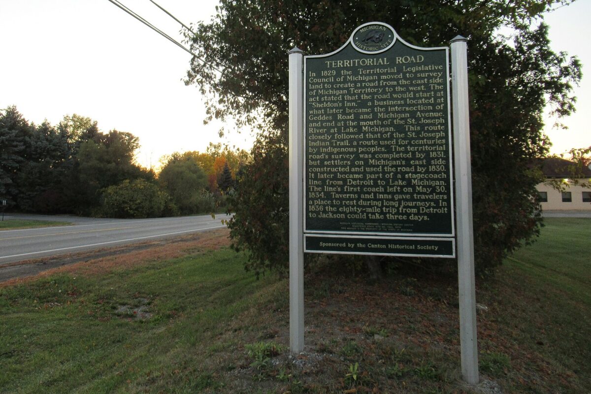
A sign on Territorial Road in Canton, MI. Credit: Wikimedia Commons (https://creativecommons.org/publicdomain/zero/1.0/deed.en)
Territorial Road isn’t just a name you see on a street sign. It’s a throwback to Michigan’s days before it was even a state. Michigan first became a US territory in January of 1805 when President Thomas Jefferson signed the act officially separating it from the Indiana Territory. The split was motivated by geographical inconvenience and ineffective governance from the Indiana Territory capital, Vincennes. With 350 miles and no real roads between Detroit and Vincennes, communication was slow, and Detroiters were even missing out on voting. Understandably, Michiganders were dissatisfied and petitioned to govern themselves. As a result of their efforts, the Michigan Territory was born, along with its own territorial government, and Detroit was designated as its capital.
Territorial Road got its start in 1829, when Michigan’s Legislative Council decided it was time to connect Detroit to the St. Joseph River with a proper road. By 1831, the land was surveyed, and by 1834, stagecoaches were bouncing along the path. The road quickly became a pioneer superhighway—think of it as the I-94 of its time—connecting settlers in the east with opportunities in the wild, untamed west (which, back then, meant places like Kalamazoo and beyond).
The road was a game-changer. It opened up Michigan’s interior to waves of settlers from the East Coast and gave farmers and traders a way to move goods. With better roads came bigger dreams, and between 1830 and 1840, the Michigan Territory’s population exploded, growing by 250%!
But Michigan’s first east-west routes weren’t exactly a fresh idea. Long before the settlers arrived, Native American tribes had already mapped trails across the region. When settlers started arriving in greater numbers, they often followed these Indigenous routes, especially the St. Joseph Indian Trail. That trail eventually inspired an official road project from Canton to St. Joseph, drawing even more people to the Michigan Territory.
5. Baseline Road
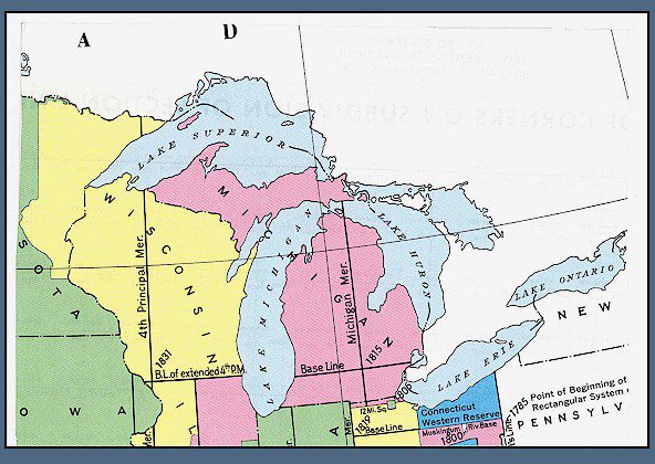
A map depicting the meridian lines in Michigan. Credit: US Bureau of Land Management
I didn’t expect much from a road named after a word you’d find in a struggling company’s quarterly report. Baseline Road proved me wrong.
The name of this road is as literal as it can get, referring to the baseline used to survey all of Michigan. Back in the early 1800s, as Michigan transitioned from a territory into statehood, the federal government needed to map the land for sale, settlement, and development. To do this, surveyors used a grid system based on a north-south “meridian line” and an east-west “baseline.” In Michigan, that baseline was established at what is now called Baseline Road. It literally formed the foundation for dividing up property boundaries, roads, and townships across much of the state.
When surveyors first laid out this baseline, they were dealing with thick forests, swamps, mosquitoes, and other conditions that made their job brutal and arduous. But their work created the framework for Michigan’s cities and farmland, allowing settlers to buy parcels of land with consistent, standardized measurements. Without this invisible grid, Michigan’s development would have looked completely different.
Today, Baseline Road still sits along that original survey line, quietly marking one of the most important reference points in the state’s history. It’s one of those roads you can drive on without even realizing you’re traveling across the line that shaped how Michigan grew. And while I’ve never driven on a stretch of road with an actual “Baseline Road” sign, chances are you have without knowing it, because one of the most famous stretches of it is none other than 8 Mile Road, which has its own reputation and history.
So while “Baseline Road” might not sound flashy, it’s a living reminder of how the state itself was carved out, one measured line at a time.
6. Fort Street
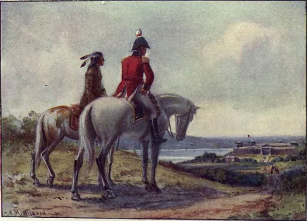
This painting pictures two men awaiting a response after sending a message that demanded the surrender of Detroit in 1812. Credit: Wikimedia Commons (https://creativecommons.org/publicdomain/mark/1.0/)
Despite the fact that when I hear “fort,” my mind immediately flashes a vision of a pillow fort or a snow fort, Fort Street points directly to Detroit’s military past.
Fort Street, also known as M-85, is named after Fort Lernoult, which was a defensive military fortification built by the British army in 1779, during the American Revolutionary War. Its strategic location in Detroit was meant to protect British interests and control access to the Detroit River. The fort was later renamed to Fort Detroit in 1805 by US Secretary of War Henry Dearborn. After the United States gained control of Detroit in 1796, the fort continued to serve a military purpose, especially during the War of 1812. The fort was eventually finally renamed to Fort Shelby in 1813, but as the city expanded, the fort eventually became obsolete and was dismantled. Despite this, the name “Fort” stuck to the area.
During the mid-19th century, Fort Street evolved from a simple road leading toward the old fort into a major thoroughfare connecting Detroit to communities farther south, like Trenton and Gibraltar. The road’s design and location made it ideal for shipping and manufacturing, which is why today you still see so many industrial sites along its path.
Over time, Fort Street became much more than a remnant of military history. It became an artery of Detroit’s industrial growth, carrying workers to auto plants and transporting goods to and from the riverfront. Today, Fort Street remains one of Detroit’s major east-west routes, linking downtown to key industrial and commercial zones.
Author

5 times labor unions made history in Michigan
Labor reform and Michigan go hand-in-hand. Take a trip through history to explore the legacy of Michigan labor unions and their enduring benefits...
13 notable stops along Michigan’s Underground Railroad
Did you know that Michigan was home to over 200 stops on the Underground Railroad? We traced our state’s history in facilitating steps to freedom....

That one time in Michigan: When marijuana was legal for 22 days in 1972
Explore the unique history of cannabis in Michigan, from a star-studded Ann Arbor rally to a three-week reprieve from marijuana laws in the 1970s. ...

That one time in Michigan: When it was the first English-speaking government to abolish the death penalty
In Michigan, a death penalty ban was established before official statehood. Here’s how this restriction came to be and what it means for modern...
‘The legend lives on’: Wreck of the Edmund Fitzgerald still resonates 50 years later
MARQUETTE, Mich. (AP) — Spend enough time along the shores of Lake Superior and it won’t be long before there’s some reminder of what happened “when...