
Snow covered berries on a tree. (USA Today Network)
Traveling in Michigan this week may be rough, as a clipper system moves in late Monday afternoon, Dec. 8, bringing heavy snow and freezing rain to parts of the state.
Weather officials have issued a winter storm warning for eastern Mackinac County, which could get 11 inches of snow by Thursday morning, Dec. 11.
Northwest Lower Peninsula counties are under a winter weather advisory with some areas getting up to 11 inches of accumulation, and possibly freezing rain. Snow belt areas are also forecast to see whiteouts as strong gusts up to 35 mph may blow snow around.
To the south and east, accumulations will be lighter, though a freezing drizzle is forecast for metro Detroit, mid-Michigan and southwest areas, creating dangerous early-morning commutes Tuesday.
“A very cold start this morning with wind chills in the single digits will see temperatures warm into the mid 20s for a high,” said the Detroit National Weather Service on X on Dec. 8. “A couple rounds of snow/wintry weather then begins starting tomorrow morning and again tomorrow night (Dec. 9) through Wednesday (Dec. 10).”
Temperatures in the Lower Peninsula are forecast to range in the upper 20s to 40, with Coldwater seeing the warmest high Tuesday of about 40. Overnight lows will be in the teens to 30s. The Upper Peninsula will see highs range in the 20s, dropping to the teens or single digits at night.
“Colder air returns Wednesday evening (Dec.10) with a bit of additional light snow possible, followed by the next arctic airmass heading into the weekend when wind chills drop below zero,” the NWS said.
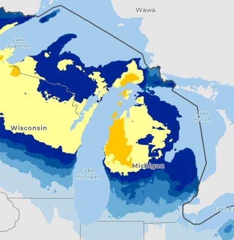
Predicted snowfall amounts for Michigan by Thursday morning, Dec. 11. Yellow-orange shading indicates higher accumulations at 5-11 inches. Blue shading indicates lighter amounts at 0.1-4 inches. (USA Today Network)
Here’s the National Weather Forecast for Dec. 9-11 across Michigan:
When will there be freezing rain in Detroit this week?
“Active weather stretch continues early Tuesday with morning snow translating to 0.3-1.5 inches of new snowfall,” the NWS in Detroit said in a hazardous weather outlook. “Areas of light freezing rain/drizzle possible during the day Tuesday as temperatures rise to around the freezing mark. Snow then briefly returns Tuesday night before changing over to liquid rain for most of Southeast Michigan. Areas along/north of M-46 could maintain all snow leading to accumulations in excess of 3 inches.”
Here’s the forecast for Detroit:
- Dec. 9: Snow likely, mixing with freezing rain after 11 a.m., then gradually ending. Cloudy, with a high near 35. Gusts as high as 28 mph. Little or no ice accumulation expected. New snow accumulation of less than 1 inch possible. At night, snow likely before 10 p.m., then rain and snow between 10 p.m. and 1 a.m., then rain after 1 a.m. Low around 31.
- Dec. 10: Rain before 4 p.m., then a chance of snow. High near 39. Gusts as high as 29 mph. At night, a chance of snow before 7 p.m. Mostly cloudy, with a low around 20.
- Dec. 11: Partly sunny, with a high near 29. At night, mostly cloudy, with a low around 18.
Will it snow in Lansing?
“There is a chance of some freezing drizzle developing late tonight that could produce a light glaze on roads and make them slick,” the NWS in Grand Rapids said. “Roads are likely to be slick for most of the area Tuesday morning with a fresh layer of snow and some freezing drizzle possible. Snow will spread in over the area Tuesday evening, and cause roads to become or continue to be slick across the area. The snow will continue across Central Lower with a few inches of accumulations likely. Areas along and south of I-96 are likely see precipitation change to rain Tuesday night into Wednesday morning, before changing back to snow Wednesday afternoon.”
Here’s the forecast for Lansing:
- Dec. 9: Snow likely before 10 a.m., then snow and freezing rain between 10 a.m. and 1 p.m., then a slight chance of snow after 1 p.m. Cloudy, with a high near 35. Gusts as high as 29 mph. At night, rain possibly mixed with snow. Low around 29. An inch of accumulation expected.
- Dec. 10: Snow, possibly mixed with rain before 1 p.m., then a chance of snow. High near 37. At night, mostly cloudy, with a low around 16.
- Dec. 11: Mostly cloudy, with a high near 27. At night, a chance of snow after 1 a.m. Mostly cloudy, with a low around 15.
How much snow is expected in Grand Rapids?
Here is the forecast for Grand Rapids:
- Dec. 9: Snow and freezing rain likely before 11 a.m., then snow likely between 11 a.m. and 4 p.m., then a slight chance of drizzle and snow after 4 p.m. Cloudy, with a high near 35. At night, snow mixed with drizzle before 7 p.m., then rain, possibly mixed with snow. Low around 30. New snow accumulation of less than one inch possible.
- Dec. 10: Snow, possibly mixed with rain before 1 p.m., then a chance of snow. High near 37. At night, snow. Mostly cloudy, with a low around 18. New snow accumulation of less than a half inch possible.
- Dec. 11: Snow. Mostly cloudy, with a high near 27. At night, snow. Mostly cloudy, with a low around 17.
Will it be snowy in southwest Michigan this week?
Here’s the forecast for Coldwater:
- Dec. 9: Snow before 1 p.m. Cloudy, with a high near 35. Gusts as high as 30 mph. At night, rain, possibly mixed with snow becoming all rain after 4 a.m. Low around 29.
- Dec. 10: Snow, possibly mixed with rain before 1 p.m., then a chance of snow. High near 37. Gusts as high as 30 mph. At night, more snow with a low around 17.
- Dec. 11: Snow, mainly before 1 p.m. Mostly cloudy, with a high near 26. At night, snow. Mostly cloudy, with a low around 13.
Here’s the forecast for Kalamazoo:
- Dec. 9: Snow and freezing rain before 9 a.m., then a chance of snow between 9 a.m. and 4 p.m., then a slight chance of drizzle and snow after 4 p.m. Cloudy, with a high near 35. At night, rain possibly mixed with snow, becoming all rain after 1 a.m. Low around 29.
- Dec. 10: Snow, possibly mixed with rain, becoming all snow after 1 p.m. High near 37. At night, snow likely. Mostly cloudy, with a low around 17.
- Dec. 11: Snow. Mostly cloudy, with a high near 27. At night, possible snow. Mostly cloudy, with a low around 14.
Here’s the forecast for St. Joseph:
- Dec. 9: Snow before 1 p.m. Cloudy, with a high near 40. Breezy, with gusts as high as 30 mph. At night, rain with a low around 33.
- Dec. 10: Rain and snow, becoming all snow after 4 p.m. High near 40. Gusts as high as 35 mph. At night, snow mainly before 1 a.m. Cloudy, with a low around 24.
- Dec. 11: Snow. Mostly cloudy, with a high near 29. At night, snow. Cloudy, with a low around 21.
Will northern Michigan see blizzard-like weather this week?
“Potential exists for impactful snow across portions of eastern upper and northwest lower Michigan late this afternoon into Tuesday, especially in south-southwest flow favored snow belts,” the NWS in Gaylord said. “Another system is expected to arrive Tuesday night – Wednesday, bringing increased potential for more widespread impactful snow to much of northern lower Michigan.”
Here’s the forecast for Gaylord:
- Dec. 9: Snow before 10 a.m., then snow mainly between 10 a.m. and 1 p.m. Areas of blowing snow. High near 30. Gusts as high as 30 mph. At night, snow before 1 a.m., then snow after 1 a.m. Low around 21. Up to 3 inches of snow expected.
- Dec. 10: Snow mainly before 1 p.m. Mostly cloudy, with a high near 28. At night, scattered snow. Mostly cloudy, with a low around 15. 2 inches of snow expected.
- Dec. 11: Snow. Mostly cloudy, with a high near 24. At night, snow mainly after 1 a.m. Mostly cloudy, with a low around 13.
Here’s the forecast for Traverse City:
- Dec. 9: Snow before 10 a.m., then snow mainly between 10 a.m. and 1 p.m. Areas of blowing snow. Mostly cloudy, with a high near 33. Gusts as high as 30 mph. At night, snow before 1 a.m., then snow after 1 a.m. Low around 24. 3 inches of snow expected.
- Dec. 10: Snow mainly before 1 p.m. Cloudy, with a high near 32. At night, snow. Mostly cloudy, with a low around 21.
- Dec. 11: Snow showers. Mostly cloudy, with a high near 28. At night, snow. Mostly cloudy, with a low around 18.
Here’s the forecast for Alpena:
- Dec. 9: Snow before 10 a.m., then between 10 a.m. and 1 p.m. Areas of blowing snow. Cloudy, then gradually becoming mostly sunny, with a high near 32. At night, snow before 1 a.m., then after 1 a.m. Low around 22. 2 inches of snow expected.
- Dec. 10: Snow possibly mixed with rain, becoming all snow after 10 a.m. with a high near 33. 2 inches of snow expected. At night, mostly cloudy, with a low around 18.
- Dec. 11: Mostly cloudy, with a high near 27. At night, snow after 1 a.m. Mostly cloudy, with a low around 16.
Where will snow fall in the Upper Peninsula this week?
The most snow will accumulate in the eastern UP at 1 inch per hour rates expected east of Manistique on M-28 late on Monday, Dec. 8, according to the Marquette NWS.
“Lake effect snow Monday evening transitioning to widespread snow overnight through Tuesday morning. Total snow accumulations between 3 and 8 inches, highest amounts near the Mackinac and Chippewa county borders,” the NWS in Gaylord said. “A Winter Weather Advisory is in effect for Southern Schoolcraft and Luce counties where lake effect snow transitioning to system snow will bring 3-8″ tonight through Tuesday morning.”
Here’s the forecast for Marquette:
- Dec. 9: Snow. Cloudy, then gradually becoming mostly sunny, with a high near 29. At night, snow. Low around 20.
- Dec. 10: Snow mainly before 1 p.m. Patchy blowing snow between 8-10 a.m. Mostly cloudy, with a high near 28. Gusts as high as 30 mph. At night, snow. Mostly cloudy, with a low around 18.
- Dec. 11: Snow. Mostly cloudy, with a high near 25. At night, snow mainly after 1 a.m. with a low around 15.
Here is the forecast for Sault Ste. Marie:
- Dec. 9: Snow before 10 a.m., then between 10 a.m. and 1 p.m. Areas of blowing snow. Mostly cloudy, with a high near 29. At night, snow before 1 a.m., then snow likely after 1 a.m. Mostly cloudy, with a low around 16.
- Dec. 10: Snow mainly before 1 p.m. Partly sunny, with a high near 24. At night, snow mainly before 1 a.m. Mostly cloudy, with a low around 11.
- Dec. 11: Snow after 1 p.m. Mostly cloudy, with a high near 24. At night, snow. Mostly cloudy, with a low around 12.
Here’s the forecast for Ironwood:
- Dec. 9: Snow likely after noon. Mostly cloudy, with a high near 24. At night, snow. Low around 15.
- Dec. 10: Snow mainly before noon. Mostly cloudy, with a high near 23. At night, mostly cloudy with a low around 4.
- Dec. 11: Mostly cloudy, with a high near 16. At night, snow. Mostly cloudy, with a low around 2.
Contact Sarah Moore @ [email protected]
This article originally appeared on Lansing State Journal: Snow, freezing rain for Michigan. Where to expect ice, bad roads
Reporting by Sarah Moore, Lansing State Journal / Lansing State Journal
USA TODAY Network via Reuters Connect
Author

Northern Michigan—no stranger to wild weather—tries to cope with days of no power
MICHIGAN—The tip of Michigan's mitten struggled through another day without electricity Tuesday as restless residents tried to stay warm while...

Here’s how Michiganders can make this winter less ‘ruff’ for their pets
As temperatures drop to below freezing, here’s what Michiganders can do to keep their pets warm and safe this winter. Michigan winters can be...

Political grudges, conspiracy theories could undermine disaster relief under Trump
Donald Trump’s history of punishing disloyalty and Republicans’ amplification of conspiracy theories could undermine disaster relief efforts if...

How to celebrate Superb Owl Sunday in Michigan (no, it’s not a typo!)
By Ellery Weil, Good Info News Wire February 5, 2024 The middle of February can bring many different things — we've heard the predictions of...
